


snowhow freeride
Descrizione di snowhow freeride
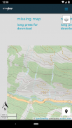
The SNOWHOW-Freeride App offers offline use of maps from the Alps. With an adjustable layer you can check the incline (steepness) of the slopes.
The slope incline is a key parameter for European decision making strategies in wintery and avalanche prone terrain.
The SNOWHOW-Freeride App is no substitute for any other tools of orientation and decision making and necessary safety gear. Shown tracks and map information are not recommendations for any terrain use.
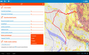
Track recording:
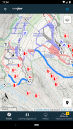
The GPS-function of your phone allows you to find your current position on the map.
Combined with the color coding of the slope incline, you can evaluate the terrain around you.
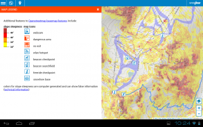
Color coding for incline:
The color coding shows the steepness of the terrain in four sectors.
These sectors are used in decision making strategies in Europe. The knowledge and correct use of decision making strategies (see http://goo.gl/y5Rmx ) is essential to be able to use the SNOWHOW-Freeride App properly. If you are not familiar with any kind of decision making strategies or any other knowledge about decision making in avanlanche prone terrain, do not use the SNOWHOW-Freeride App.
Resolution and color coding:
Each color coded tile shows an area of 10 x 10 metres or real terrain. Keep in mind, that within 10 metres the steepness of a slope can change dramatically.
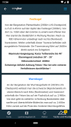
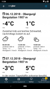
Weather data and Avalanche Bulletin:
If you go online with your smartphone, the SNOWHOW-Freeride App will automatically load the newest avalanche bulletin.
L'app SNOWHOW-Freeride offre l'uso offline delle mappe delle Alpi. Con uno strato regolabile è possibile verificare l'inclinazione (pendenza) delle pendenze.
L'inclinazione del pendio è un parametro chiave per le strategie decisionali europee in terreni invernali e soggetti a valanghe.
L'app SNOWHOW-Freeride non sostituisce altri strumenti di orientamento e decisione e gli equipaggiamenti di sicurezza necessari. Le tracce mostrate e le informazioni sulla mappa non sono raccomandazioni per qualsiasi uso del terreno.
Traccia la registrazione:
La funzione GPS del telefono consente di trovare la posizione corrente sulla mappa.
In combinazione con il codice colore dell'inclinazione del pendio, puoi valutare il terreno intorno a te.
Codice colore per inclinazione:
La codifica a colori mostra la pendenza del terreno in quattro settori.
Questi settori sono utilizzati nelle strategie decisionali in Europa. La conoscenza e l'uso corretto delle strategie decisionali (vedi http://goo.gl/y5Rmx) è essenziale per poter utilizzare correttamente l'app SNOWHOW-Freeride. Se non si ha familiarità con alcun tipo di strategia decisionale o qualsiasi altra conoscenza del processo decisionale in terreni soggetti a avanlanche, non utilizzare l'app SNOWHOW-Freeride.
Risoluzione e codice colore:
Ogni tessera con codice colore mostra un'area di 10 x 10 metri o terreno reale. Ricorda che nel raggio di 10 metri la pendenza di una pendenza può cambiare radicalmente.
Dati meteorologici e bollettino valanghe:
Se vai online con il tuo smartphone, l'app SNOWHOW-Freeride caricherà automaticamente il bollettino valanghe più recente.
snowhow freeride - Versione 2.0.26
(02-11-2021)snowhow freeride - Informazioni APK
Versione APK: 2.0.26Pacchetto: info.snowhowUltima versione di snowhow freeride
Altre versioni


App nella stessa categoria

Potrebbe piacerti anche...